Sunday, September 3, 2017

Peak Lenin: part 2

If you haven't read "part 1" yet I recommend doing so first.

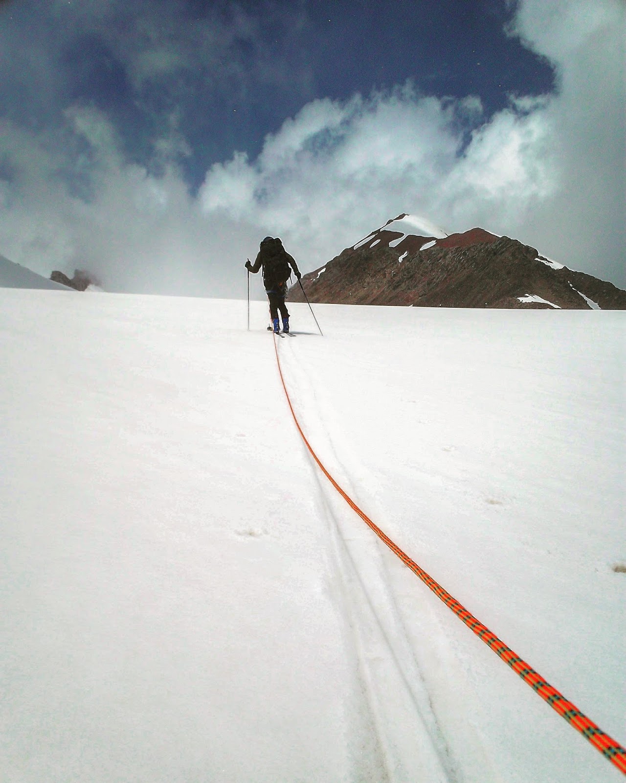
The route between ABC and Camp 2 (C2) is glaciated and features the biggest objective hazards of the route (excluding the altitude itself), with numerous crevasses and also some overhead hazard from avalanche paths on the north face. I was happy to be able to tie into the same rope as Stephan and Rafael in order to get up there a bit more safely. We set out around 4am in order to get off the route before the heat of the day caused snow bridges to start weakening and the avy hazard to start increasing.

Raphael and Stephan cruising over the glacier towards C2.
They would sporadically break in to singing traditional Austrian climbing songs mid stride- a custom I'm planning on emulating in the future.
The route itself was technically straight forward, the steepest slope being in the mid/ high 30s. And the few sections which were heavily crevassed featured fixed ropes, but there weren't many people actually clipping in to them. The crux of the route of was crossing a 3 metre snowbridge which spanned a crevasse and required a small mantle move made somewhat awkward by the heavy pack. We made slow but steady progress, stopping once an hour for a drink break and to take photos. By a little past 9am we were in C2 and set about getting tents pitched.


I was happily surprised to find that the campsite had a source of running water, meaning that we were saved the hassle of melting snow.

After digging and chipping out a small platform for the tent I settled in for a day of rest, utterly unaware the I was in for the most uncomfortable tent bound experience I've ever had in my life, for a reason which was completely unexpected at an altitude of 5400metres: the heat! By around 11am the sun was blazing down and it felt like the surrounding slopes were refracting all the energy directly onto the camp site. There wasn't a breath of wind, and the tents turned into little pressure cookers: I measured 47 degrees celsius (117 farenheit) in my tent, whilst another guy whose tent was at a lower site measured 52 celsius. Outside wasn't much better in terms of temperature and it had the significant drawback of serious sunburn being unavoidable if you weren't properly covered up. The end result was me lying prostrate on cool floor of my tent in my boxer shorts and periodically cooling myself down with handfuls of snow. Not exactly what I'd been expecting.

Once the sun dipped behind the ridge around 5pm the mercury plummeted, meaning that I went from lounging around in a state of mild heat stroke to happily wrapped in a sleeping bag rated to -20 in the space of one hour.

The following day I joined Rafael and Rob on an acclimatisation effort up to C3 and Peak Razdelnaya at 6148m. In the process improving on my five year old max altitude record. To be perfectly honest I was feeling pretty terrible above 6K; dizzy spells, heavy breathing even at rest and a level of effort which I'd usually associate with an ascent rate of 1200m/ hour, not the 200m/hour which I was actually covering. More disconcerting however was the bizarre mental state I found myself in, which could best be describe as a sort of dissociation from myself: a strange sense of derealization complete with mild dolly zoom effects. I was present enough to understand that it would be wise to clip into the skis and start descending pronto, and once I'd dropped a few hundred metres the symptoms were gone.


Modelling my improvised nose guard at around 6050m, near Camp 3. Photo by Georgio.


A little video captured by Ernst.

The following day I went back up to C3 solo. The ascent only took 2.5 hours this time and I was feeling a lot better so opted to hang out and spend 3-4 hours at that altitude in order to squeeze a bit more acclimatisation out of the day. Whilst I was sitting around I met a fellow from Almaty in Kazakhstan who was going for a ski descent of the north face the following day. Sitting in his tent he showed me photos from some of the skiing he has access to close to his home town- and I found myself with another location on my list of future ski trips. He made this video which does a pretty good job in summarising the trip and ski conditions (and features a quality soundtrack).

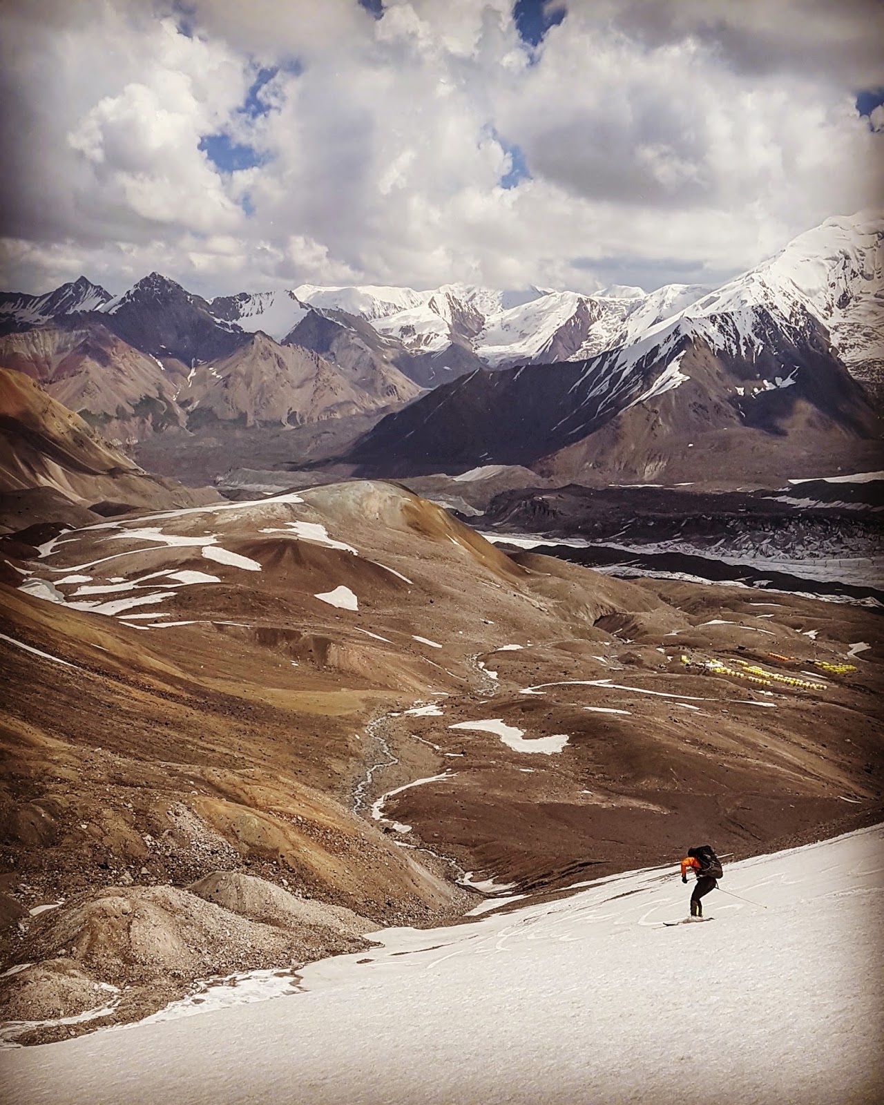
Spent another night at C2 and the next morning left a bunch of gear (gas, food, warm/high altitude clothes) in my tent before skiing back down to ABC for a rest day. (I had two tents on the mountain; one which was more spacious and comfortable albeit heavy for BC/ABC, and one smaller/lighter high altitude tent for the upper mountain).

Skiing back down the glacier to ABC
I opted to descend the glacier on skis rather than being roped up. It went smoothly and actually offered some enjoyable firn snow. I was a little apprehensive about negotiating the crux solo, and was mildly alarmed to discover that the snow bridge which we had crossed three days prior had collapsed completely, leaving a 3 metre wide chasm that I couldn't see the bottom of.

We had crossed this crevasse on a snowbridge just a few days prior.
Halfway down the route I turned to a stop near a climber who was sitting on his pack. He asked for my help and I sidled over to see what the situation was. He explained that he was part of a guided group who was ascending to C2, but he had started showing symptoms of a pulmonary edema and had wisely opted to descend back to ABC. There was another client from the same group with him helping him down, but the guide was no where to be seen. He was was still able to move under his own power, but needed to rest often, and wanted me to alert the company who was organising his trip down at ABC. I got his details, watched as he gave himself a dex injection and continued the descent, trying to find a good balance between moving fast and not making any stupid mistakes as I contoured between the crevasses. Once I arrived at his ABC I found the guy in charge of radio communications with their guides and it became obvious that the guide himself was utterly clueless as to the situation which had unfolded. There conversation went something like this:
ABC: What is your location?
Guide: I'm nearly at Camp 2.
ABC: Do you have a client with AMS who is descending?
Guide: I don't know, some of the group were slow, so we left them to continue the ascent on their own.

Wildly lax approach that some of the local outfits seemed to have...

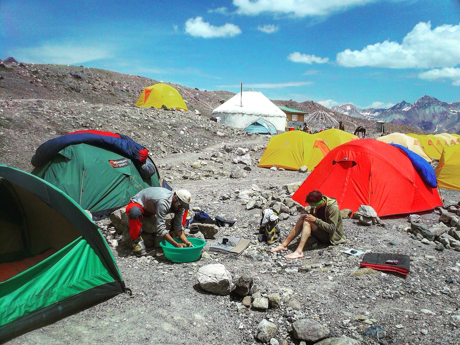
Rest day activities at ABC
By this stage, after a little over two weeks on the mountain ABC was a beacon of comfort: the relatively rich air, the smooth gravel the tents are pitched on and the luxury of a pit toilet- all of it felt like a fancy hotel after being higher on the mountain. After a 1.5 days of rest down at ABC it was time to head up high again for a summit push. According to the vague weather reports there was going to be a high pressure system moving in in a few days time, and it seemed that this would time perfectly with a summit day. There were also a bunch of other climbers from ABC who I'd gotten to know over the previous weeks who were on the same schedule, and it appeared that around 7 others would also be making a summit attempt on the same day.

The  climb back up to C2 was much easier than the last time, owing to a lighter pack and being better acclimated. The glacier was obviously melting rapidly though, with numerous crevasses having opened up in the previous two days. The rest of the day at C2 was uneventful save for a mishap at the lower area of the camp where a German guide punched through some rotten snow, fell 6 metres down a crevasse and had to be evacuated down to ABC from where he got a heli-evac the following day after apparently suffering a few spine fractures.

The next morning it was simply a matter of repeating the climb to C3 and spending the remainder of the day hanging out with Stephan and Raphael: melting snow and drinking tea. I went to bed around 6pm, listening to music on my mp3 player and anticipating the day to come.

Camp 3 and the summit of Lenin looming in the distance
My alarm sounded at 2am and I didn't waste any time re-boiling 3 litres of water (which I had kept warm in my sleeping bag overnight) and drinking some Nesquick for breakfast before crawling out of my sleeping bag and into the night. I could see lights on in the other tents and hear folks getting organised for the climb, but rather than wait around I clicked in to my skis and started out a little before 3am.

The route started with a 100 metre descent down to a col, the snow conditions left a bit to be desired, and with the limited light from my headlamp I was careful and skied tentatively. Down at the col I put crampons on and strapped the skis to my pack. The wind was stiff and the temps cold enough that I climbed up in both my synthetic jackets. The first 400-500 metres of climbing followed a windswept ridge, in some places snow whilst in other places scree, at an incline in the upper 20s/ lower 30s. I passed two climbers in this section and continued up, finally reaching (the rarely used) Camp 4. The next section of the route was rather flat and proved a welcome relief to my oxygen starved lungs. As I continued plodding slowly onward I was witness to a spectacular sunrise. Cruising along alone at an altitude of 6500m and having these incredible views open up was pretty special.

Sunrise from 6500metres.
The "crux" of the summit day is a section called "the knife" which is basically just a broad fin of snow about 45 degrees and 50 vertical metres with a fixed rope on it. If you've got an axe and know how to use it (and don't feel too wobbly from the altitude) you don't really need to use the rope, but I still clipped my tibloc on to it for a bit of extra security as I booted up. I was feeling a bit wrecked from the altitude (but making steady progress) and decided that with the reports I'd read about the upper most section of the regular route rarely being skiable due to lack of snow cover I stashed my skis below the knife- figuring that there was no need to waste my energy carrying skis up to the summit if I wasn't going to be able to use them on the descent

The final stretch to the summit isn't really visible from below and is quite meandering. But the snow conditions turned out to be decent enough that skiing would indeed have been possible for at least 70% of the route. Oh well... At this stage I didn't really give a fuck, I just wanted to tag the summit and get back down to an elevation where I could breathe some thicker air.


My pace slowed considerably and I fell in to the habit of walking for 10-50 metres and then stopping for a quick break. The entire time I was focused on proper breathing technique, forcefully pushing all the air out of my lungs in order to maximise my oxygen uptake, but even this was proving inadequate on the final 200 metres. The convexity and irregularities of the upper part of the route meant that I only got a view of the summit when it was 15 metres away. I sat down next to the bust of Lenin's head a little past 9am, having spent about 6 hours on the ascent from C3. I spent about 15 minutes on the summit, took a few photos and headed down.


On the way I passed Paul, Georgio, Troels, Raphael, Stephan and Kyle, stoked that they were all guaranteed to make the summit themselves. After what felt like a very long time I was back at C3, feeling pretty terrible, and contemplating heading down to C2 and some thicker air. I decided to drink some water and rest in the tent and wait for the others to return however. And after dozing in my tent for an hour I suddenly felt like myself again, and the prospect of the heat down in C2 was very unappealing. 

Raphael and Stephan about half an hour from the summit
The following morning I woke at 6.30am, packed up camp and skied down to C2 where I met Raphael and Stephan who had hiked down a little earlier. I'd already decided to descend the glacier on a rope due to its rapidly melting state and was happy to be able to tie in to theirs again. At ABC I packed up the other tent and a bunch of extra gear I had stashed down there. I had been hoping to pay one of the dudes with a horse some money to carry some of my gear the 12 km back to BC, but sadly they had already headed down. So I drank a litre of coke, ate some walnuts, stuffed some nasvai under my lip and got some help lifting the monster 34kg load onto my back for the walk back down. By 2.30pm I reached BC and organised a car for the drive back to Osh for later that afternoon. At BC I jumped on some scales and discovered that I had lost 7kg over the 18 days I spent on the mountain. By 10pm that night we were back in Osh, pretty wild to have woken at 6100m and gone to sleep at 900m.

It felt pretty marvellous to get back to civilisation. And I spent the next week hanging out with Stephan and Raphael in Osh and travelling up to Bishkek in a shared taxi with them. We ate a lot(!) of food and got some really cool shirts at the Osh Bazaar.

Thanks to Bjarte for the camaraderie on the lower parts of the mountain and to Raphael & Stephan for the same on the upper parts, as well as all the other cool people I met for helping make the trip such a memorable climb/ski.

Also thanks to Höjdmeter for the support with gear. 
And Expedition Foods for the discount on their excellent freeze dried meals.
And Markus P for lending me his sleeping bag.

Friday, August 18, 2017

Peak Lenin: part 1

About a year ago when I realised that my summer vacation from nursing studies would last from mid June to mid July I began wondering about potential locations for a little adventure in the mountains. This isn't a season I'm used to having free from work and I wanted to go somewhere with my skis where these few months at the height of summer were actually prime season. After a bit of research I realised it was time to return to Kyrgyzstan (I was there in June/July 2010), but this time check out some higher peaks in the Pamir range.

Preliminary planning with Peter had me really excited about some potential lines on Pik Dzerzhinsky with Pik Lenin as a backup plan, or something to do afterwards when we were fully acclimatised. Some changes in the group lineup, with Peter unable to join us and Bjarte only being able to spend 10 days on the mountain, meant that plans evolved and were down graded to focusing on Lenin as the primary objective. The main reason simply being that the level of uncertainty and exposure on the aforementioned objectives was something that I was unwilling to stomach as a solo venture.

Shopping in Osh bazaar. Photo by Bjarte

Shopping in Osh bazaar. Photo by Bjarte

Bjarte and I met at Arlanda airport on July 12th and re-distributed some of the luggage before three unremarkable (albeit for getting stung for 10 kilos of overweight carry-on luggage at Istanbul to the tune of 10USD/kg) connecting flights to Osh. We had most of our food for the trip organised, but went to the bazaar to stock up on some dried fruit and nuts. We also got our transport from Osh to the Achik Tash basecamp organised with help from our wonderfully friendly and capable host Remi.

Enroute to basecamp in a Lada Niva. Photo by Bjarte

BC lies in a broad valley of green pasture at an altitude of 3600 metres. There are about half a dozen different operations which have bases there, offering accommodation in tents, meals in communal yurts, selling bottles of coca cola and vodka as well as gas canisters and souvenir t-shirts, some of the joints even have banya tents! We were going on a budget, self-supported style trip (like approximately 5% of the other people we met on the mountain) and only paid for a place to pitch our tent for the night, which also provided us with a measure of security against theft which we'd read could be a problem, in addition to access to their toilets and washbasins.

Motivation levels were sky high on day 1. With bluebird skies and the feeling that we had no time to lose, we decided to load up our backpacks with gear and food for higher on the mountain and ferry a load up to advanced base camp. This was a round trip of about 24km and 1100 metres of elevation gain with loads of around 25kg. Our progress on this first day can best be described as slow and steady, we were trying to be careful to manage our pace and exertion- careful not to wreck ourselves pointlessly. But in hindsight we were definitely pretty eager and probably pushed ourselves a bit too hard, something we would pay the price for in the coming days.

Views from BC on day1

Bjarte carrying a load on our first rotation to ABC


Carrying a load to ABC with Peak Lenin looming in the background. Photo by Bjarte


We got to ABC around midday and stashed the gear and food in a storage tent belonging to one of the tour operators. We met a young guy from Sweden who had just returned from Camp 2 and talked a little about the route and some of the objective hazards with the crevasses, seracs and avalanche paths and the importance of starting by 4am at the latest when ascending to C2. As we were standing around eating an energy bar for lunch and admiring the views we suddenly heard a few people shouting and looked up to see a huge (size 4) avalanche tearing down the north face and engulfing a section of the regular route between ABC and C2. Bjarte managed to snap the photo below.


Avalanche. Photo by Bjarte

Discussion with a few of the other guys milling around in ABC immediately turned to how there were definitely people on the route. (Bjarte learned from chatting to some folks at BC later in the week that 8 (?) people had been knocked off their feet by the air blast which preceded the powder cloud and pushed 50-100metres downslope- but miraculously no one was killed). The event left a lasting impression on everyone who witnessed it. These mountains were obviously unforgiving, and while the standard route to the summit, which is regularly described as being the "easiest 7000 metre peak", might be technically straight forward, "easy" does not equate to "safe".

We shouldered our packs and hiked back to basecamp, arriving in mid afternoon.

Bjarte and David hiking back to BC.

We were keen to test out the skis on day 2 and opted to do so on a small, rather flat looking glacier we had spied the previous day whilst hiking to ABC. Waking up at 5am we made a quick breakfast of porridge which I was uncharacteristically unable to stomach- my appetite was meagre to start with and the sight of the gloppy oats left me feeling queezy. Undeterred, we began our slow plod up to the glacier.

After an hour or two of slow hiking I was feeling pretty nauseous, and couldn't figure out if it was due to a) the altitude (nausea is a pretty common symptom of AMS), b) having eaten something bad or c) a combination of these two factors. Bjarte wisely pointed out that if I was feeling sick it was probably best to get it out, which proved simple enough: I simply thought about that morning's porridge for 10 seconds and before I knew it I was projectile vomiting up the contents of my stomach.

In search of some skiing- early on day 2. Photo by Bjarte

I felt a little better, but our pace was still miserably slow on account of the altitude. We eventually made it to the glacier and had a short break before getting out ski boots on and roping up for the glacier. We skinned up to about 4600m (only about 200m from the snout of the glacier) before deciding that with the deteriorating visibility we ought to follow our tracks and head back to camp. The skiing was pretty marginal, but it felt good to have already been out on the skis on day 2 of the trip.

Bjarte skinning up a flat glacier on day 2.

Getting back to camp in the early afternoon we were both feeling pretty wrecked and spent the remainder of the day dozing in the tent.

The next morning we had decided it was time to move a little bit higher and continue our acclimatisation, but were also uncertain as to whether it would be a smart move to head all the way up to ABC. We ended up hiking halfway and pitching our tent at 4000m where we spent the remainder of the day relaxing in the tent and discussing how we had probably been a little to enthusiastic and ambitious on our first two days, and that this might have something to do with how wasted we were feeling.

R&R at 4000m


Waking up the next morning, Bjarte told me that he hadn't slept a wink that night. Insomnia is another common symptom of AMS, and one which I have experience from in the past- lying awake in a tent for an entire night is shitty enough as it is, but given that sleep is when the body does it's best acclimating it is doubly frustrating that you aren't even getting the same benefit as your comfortably snoozing tent mate. Bjarte was keen to head down to BC for another night or two, but I was feeling relatively fine and the nausea which had plagued me the previous two days had abated, so we decided to meet up again in ABC in a few days time: Bjarte split back down to BC whilst I hiked up to ABC to continue acclimatising.

Headed up to ABC again. Photo by Bjarte


At the start of the hike I met two horseman who were transporting gear up to ABC- they told me that for 1USD per kg they would transport my mammoth backpack- I accepted happily. Arriving at ABC it was time to choose where to pitch the tent, this was going to be home for the next two weeks and there were a few factors to take in to consideration. After wandering around I decided to stay at a site just near ITMC (the Kyrgyz Apine Club's tour agency), which for only 20USD for the entire stay would give us access to their toilets and communal yurt. The real perk of staying at this site though was that there were a number of friendly English speaking climbers staying there, and with Bjarte at BC and only likely to have 2-3 days at ABC I figured it could be nice to have some folks to converse with.

The following two days I went out skiing solo, on some non-glaciated snow patches close to camp. There were a few narrow snow bands on the east face of Yukhin Peak (5100m) which skied nicely despite the thin and scratchy snow cover.

The views from ABC. Photo by Bjarte

Bjarte made it up to ABC feeling much better and more rested after his extra two nights at basecamp and slept really well the first night at this higher camp. By this stage we had both come to the conclusion that we had gone out way too hard on the first two days. Being accustomed to spending long days in the mountains back in Norway and logging plenty of vertical metres we had mistakenly fallen in to the trap of thinking we could basically just adjust our pace but still cover the same amount of terrain as what we were used to. In hindsight this was pretty stupid and naive. We had learned that climbing/skiing at altitude was really an entirely different activity, one which required enforced rest/ recovery days and a lot of time sitting around drinking tea in yurts. We opted to scale things down a notch from our original plans.

 The following day we went for another ski on Peak Yukhin. Whilst the snow quality on these descents left a bit to be desired the views whenever you glanced upwards between turns were incredible: the immense north face of Lenin and the broken glacier in the valley in between was stunning and made for a worthy distraction from all the rocks we found ourselves skiing over.

Bjarte skiing from Yukhin Peak.

Enjoying a few scratchy turns from the summmit of Yukhin Peak. Photo by Bjarte

Skiing back to ABC. Photo by Bjarte

Skiing back to ABC. Photo by Bjarte

The next morning was overcast, with intermittent rain/sleet/snowfall. We took a day off from skiing and instead spent some time wandering around the dry glacier and drinking copious amounts of tea and Nesquick (#nectarofthegods). That afternoon the temperature dropped and it started snowing. Reports from higher on the mountain (relayed via VHF radio to the camp manager) said that it had snowed over 30cm in the preceding hours at Camp 3 (6100m), and I was glad not to have any plans of heading up to C2 that night.

Wandering around the glacier on a weather day.

We woke to about 10cm of fresh snow at ABC and quickly decided to make the most of the conditions with a little skiing. Knowing that the new snow was really only enough to disguise all the rocks we opted to ski a few short laps on the snowfield close to camp which was starting to feel very familiar. Bjarte was feeling pretty drained again and opted to wait whilst Rob (a skier from the UK also staying at ITMC ABC) and I took a few very short but fun laps in the rapidly warming snow.

Rob enjoying a "bluebird pow day" near ABC. 

Back at camp by mid-morning it was time to make a decision: Bjarte was scheduled to leave from BC the following day in order to travel back to Norway and I suddenly had no climbing partner for the upper mountain. Of course this wasn't a surprise, I'd known that this was the plan from the outset, but for the past nine days I'd had mixed feelings about the prospect of heading higher on the mountain solo. There were a few new friends who said I was more than welcome to tie in to their rope to cross the crevassed glaciated section to Camp 2- which I was really grateful for. On the one hand I was still keen to head up higher on the mountain, despite the ups and downs I'd been feeling so far on account of the altitude. But on the other hand I wasn't relishing the prospect of spending a week sitting alone in a tent.

In the end, after a marathon bout of indecisiveness, I knew that after investing this much time, energy and money in to getting this far I would regret the decision of bailing now. I hugged Bjarte goodbye and made plans to join some of my new pals on the climb to Camp 2 the following morning with the alarm set for 2:50am.

Saturday, February 11, 2017

Kongsbakktinden SE face -FKD

Micke has a good eye for new ski lines. So when he invites you along on one of his projects it's usually worth rescheduling whatever it was you had planned on doing that day in order to avoid missing out on the fun.

The story of Kongsbakktinden started last April when Micke sent me an aerial photograph. I stared at the thing for about a minute before I even saw what he envisioned and decided then and there that I wanted in. Poor weather/ unsuitable snow on the days we had planned to check it out last season meant that it was added to the (already long and growing constantly) list of things to do this winter.
 
With a week long high pressure system we decided to go and have a closer look on wednesday. On the drive in and approach through the trees I was kind of sceptical that we would find the right snow conditions, but figured it was a nice day for a recon if nothing else.

 
Micke paying part of the admission price for skiing a new line.
 
We were pleasantly surprised by the snow conditions the higher we got, mostly old wind transported snow rather than the wind scoured meltfreeze crust which is so prevalent in other mountains in the area at the moment. We alternated between skinning and booting steeper sections until the upper headwall where we donned crampons and double tools for the upper section which we measured at around 50 degrees and which had an icy bed surface below the older wind transported snow.
 
A quick break to scope the proposed line which is in the center of the image
We skied from the summit. It was a blast. We didn't really get any quality photos of the steeper crux on account of us skiing pretty spaced out.


Micke jus above the rollover into the steeper crux of the route.

Fun turns and pretty views down lower

The line
Definitely a highlight of the season so far.


Tuesday, February 7, 2017

Øksehogget and another weekend in Lyngen

Eight months and roughly 200 000 metres of vert have passed since the last blog post- I don’t think I’ll bother trying to summarise the interim period suffice to say it featured plenty of enjoyable days in the hills.

This past weekend the Tromsø skimo crew organized a gathering in Lyngen and Micke and I decided to crash the party and represent the Narvik contingent. The drive up to Lyngseidet takes about four hours and passes through some pretty mountains, so we figured we ought to break up the drive and go ski something.
The something we settled on was Øksehogget. A pretty little couloir on the north side of peak 1381 just south of Lemmetfjell. It received quite a bit of media attention a few years ago when it was voted the raddest couloir in Norway by Fri Flyt magazine, beating Gagnesaksla (near Narvik). I’ll admit that I was kind of sceptical of it really being that good. I figured the voting process had somehow been skewed by the hordes of Finnish freeriders who migrate to Tamok every spring. I was happily surprised when it first came into view.
Øksehogget. It's a pretty one.

Micke the alpine ninja enroute to Øksehogget

The entrance was easy to find, and there were 5 old pieces of cord around the anchor which meant we didn’t even have to leave any ourselves.
A 20 metre rap followed by a belayed ski cut took way longer than it should have and provided a great example of how little of my skiing has involved ropes in recent years and how efficiency in rope handling really does require at least some occasssional practice. The line itself is a sustained 40-45 in the upper 300 metres of vert, where it averages 5 metres in width and slackens off to the high 30s for the lower 200 metres where it is around 10 metres wide. 
photo from Micke


Photo from Micke
It skied exceptionally well: sustained and in the fall line, and whilst I do think that calling a single ski line "the best" is a ludicrous and meaningless undertaking, I do think that things like "top 50" lists can apply to ski descents. And this line would definitely make it on to such a list over things to ski in Norway.

The route we followed wasn't exactly as outlined below, we ended up heading to the pass just north of point 1291. The quickest and most direct route is definitely heading straight up the western shoulder, but the advantage of wrapping around from the north is that you get some good visuals on the line and some info on the conditions before you rap in.

A rough version of our route:


The next two days in Lyngen were great fun: filled with quality skiing with a big group of friendly folks from Tromsø. After some technique drills on the ski slopes on Saturday morning we headed to Rørnestinden for a handful of laps on the upper slope in some magical late afternoon light.
On Sunday we drove north to Koppangen and headed up Tafeltind. Conditions were terriffic given that it's been a week since the last snowfall, and I also got a nice overview of the terrain which will be invaluable in planning the next attempt at the "Lyngen på langs" traverse. I'll let the photos speak for themselves.
A big group on little skis
Goalsevarri from Rørnestinden
Sven Are skinning up Rørnestinden with Store Kjostind in the background


Gang skinning up to Tafeltind


 View to the east from the summit of Tafeltind


 And to the west.


Friday, May 6, 2016

Lyngen på langs- nearly...

Due to a poor weather forecast and a decidedly unstable snowpack in Jotunheimen, the plans which Bjarte and I had of heading down there for a ski traverse were foiled. Late last week we made a quick decision to change our focus to some other majestic mountains just a short drive to the north; the Lyngen Alps.

We had a week off work and after briefly discussing options for simply camping out doing multiple day trips, the idea of attempting a traverse of the entire peninsula came up. Its been done several times before in a variety of different ways and following a number of different routes. The possibilities really are endless; you could spend several weeks travelling along the peninsula skiing loads of peaks along the way, or you could stick to the valleys and coastline if you wanted. One thing worth noting about Lyngen however, is how complex much of the alpine terrain is; traversing ridges and peaks in this area often requires a lot of challenging and technical alpine climbing, which means carrying the rope and all protection that is required. Being averse to carrying monster packs and loads of luxurious but extraneous equipment, and not really knowing that much about the Lyngen Alps, we opted to ski a route which is pretty standard, with some good skiing, but nothing technically demanding and to do it in a reasonably efficient manner. There was never any goal of setting a fast time or anything like that, we were mainly excited to explore some new mountains and familiarise ourself with the place.

I asked around and got some great route beta from people who were more familiar with Lyngen (a big thanks to everyone who shared tips- you know who you are!) and we ended up planning on following the same route as Espen Nordahl (the fellow behind this great book) had skied two weeks prior. In reality we ended up making a few changes due to lack of snow in certains areas, and a desire to checkout some other lines. The route we actually skied looked like this:

To see the route in detail click here
 Note that we didn't actually finish our tour at the northen tip of the peninsula, we decided to stop 11 km short, due to a lack of snow and the fact that we were pretty sick of walking in soggy ski boots by that point. But I'm getting ahead of myself....

The week prior to our traverse had been defined by the arrival of warm spring temperatures, which led to a significant avalanche cycle and a lot of snow melting in a very short space of time. With warm day time temps forecasted, we knew that early starts were going to be vital to move efficiently whilst the snow was firm and also to avoid the avalanche hazard which was greatest in the heat of the afternoon. So we started out at 2am from Nordkjosbotn after a few hours of sleep by the car.


Conditions were pretty good owing to a decent re-freeze overnight and we had a pleasant tour over to Langdalen.

Bjarte in Lysvassdalen early on day 1.

Bjarte on the first proper descent towards Kjeldalen, early on day 1.
 It was about 6am when we reached Langdalen and it felt like time for a cup of coffee so we had a quick break and I gave my ski boots a good wash when I broke through some rotten snow whilst filling water bottles in a small stream.

We continued up towards Guhkegaisa (Langdalstindene on the map) and the gentle glaciers to the east which we skinned up to reach the pass to the next drainage. On the way we got a decent overview of all the avalanches which had released a few days prior.

Bjarte with point 1404 looming in the background and a bunch of debris from recent avalanches.

Bjarte making his way across some debris below point 1214.

Looking south from near point 1214. Photo by Bjarte
We reached the small notch which gave us an entry point onto the glacier which leads down towards Ellendalen, the short north facing couloir was very icy and studded with a few rocks but looks like it would ski brilliantly in different snow conditions.

Skiing into the short couloir from the notch due east of Guhkegaisa. Photo by Bjarte.
We reached Ellendalen around 10 o'clock in the morning. It was tempting to continue skiing, we were feeling good and it was still early in the day. But with rapidly increasing temps, knowing that the next suitable campsite was over 15km away and that the snow would soon be an isothermic slurry we decided to stick with our plan of camping here, and enjoyed a lazy day/afternoon of reading and drinking soup before going to bed around 8 o'clock.

Campsite in Ellendalen for the first night.
 We woke at 2:15 the next morning and after a quick coffee and breaking camp were skinning by 2:40. The route went up the valley to Steindalsbreen, in the early morning light the mountains were looking pretty damn beautiful.

Looking back down Ellendalen early on day 2. Photo by Bjarte

Stunning early morning light at the edge of Steindalsbreeen.

The glacial plateau of Steindalsbreen.
A short ski and a gentle skin brought us to the pass just east of Nallangaisi, from which we enjoyed a fast ski down Veidalen, with a good  a crust meaning we could skate and double pole the flat sections.


Bjarte in the upper section of Veidalen.
We reached Lyngsdalen around 5:30 and decided to stop for breakfast and coffee in the sun. Then a short bootpack up to Bredalen and a gentle ski down to Kvalvikdalen. It was only a little after 8am, but the snow was already getting alarmingly warm so we opted to hike up a shoulder of scree to reach Goalsevarri.

Bjarte with Kvalvikdalstinden in the background.


I think Bjarte took this photo when we were headed up Goalsevarri, but I could be wrong...

A bit of scree hiking up to Goalsevarri made for a nice change to skinning. Photo by Bjarte
From the pass near point 1094 we skied down to Gjerdedalen and on to Lyngseidet, passing a few people setting out on ski tours on the final part of the descent it felt strange again to be finished for the day when other people were just starting out. We reached Lyngseidet around 11am and bought a pile of food from the supermarket which we enjoyed as a picnic on the balcony at the Magic Mountain Lodge.

Even though we'd only had two nights out (including the short bivvy by the car before we started), it was really nice to have a shower and enjoy the luxuries of an afternoon in civilization. As usual the hospitality and welcome provided by Patrik and Henrika was wonderful and much appreciated. We set the alarms for 2am again and settled in to some comfortable beds for the night.

Getting moving the next morning was a mental struggle for me, the sleep deficit from three consecutive days of waking around 2am was starting to take a toll on me. On the hike through town and up to the snow line at 300masl I was feeling drowsy and grumpy, once we started skinning and encountered a long stretch of breakable crust my "grumpiness" morphed into rage for a short period as I skinned along and unpredictably punched through the melt freeze crust into isothermic slop up to my knees. I was pretty disheartened that conditions were already so trying at such an ealy hour of the day and knowing that conditions were only likely to deteriorate even further. But trying to catch up with Bjarte, who is a beast and totally zen about things like breakable crust helped keep my mind off things.
This is was shitty ski conditions look like. Early on day 3.
The descent from the pass south of Fastdalstind featured a lot more breakable crust, but strangely, once we reached Russedalen the conditions improved markedly and we were skinning in warm but predictable snow up towards Tafeltinden. We had decided the night before to change our route slightly, and head up the big glacier east of Tvillingstinden. The snow here was kind of rotten and we were both struggling with skins failing due to them being totally saturated from the warm, wet snow. It felt extremely foolhardy to be setting out on this heavily crevassed glacier with out ropes, but we decided to get a closer look before making up our minds.

Approaching the glacier. We ended up taking a route up the lookers right side (not pictured in its entirety). Photo by Bjarte
 In the end, after a lot of expletives I found an okay route weaving between the crevasses and we reached the upper section of the glacier which is flat and much safer. We ripped our soggy skins at the pass between Store Jægervasstinden and Tafeltinden and skied down Lenangsbreen. This was where we finally got what would generally be described as "quality skiing", with some fun corn beside the blue glacial ice.

Halfway down Lenangsbreen. Photo by Bjarte

Bjarte enjoying some great skiing down Lenangsbreen.
Down at Blåvatnet we were faced with the decision of following the same route as Espen had, which would require a few kilometres of hiking now that the snow had melted out in the preceding week, or attempting a different route over a pass due SE of Veidalstindan. Given the warm temps and concerns of unstable snow we opted to stick with the safer albeit more arduous option of hiking...

Bjarte apparently unphased by several kilometres of rock hopping in ski boots.
 We hiked for about 2-3 hours, over rocks, through swamps, over small patches of rotten snow and through some birch forest, then traversed up to Botnfjellet where we were finally able to put our skis back on at 400masl. A short, traversing ski descent in some light rain brought us to Veidalen where we searched for a place to pitch the tent. Being tired we weren't particularly fussy and soon settled on a small, lumpy patch of heather to pitch the tent on. We'd been on the move for about 12 hours.

It should be noted here that I had chosen the tent for the trip based on a weather forecast which was calling for dry weather. The tent (BD's Firstlight) is nice and light, and offers ample protection from wind and snow but is certainly not waterproof. I knew this from earlier trips and as we cooked up some dinner and the rain battered down I knew we only had about 30 minutes before it would start seeping through. Bjarte, ever the optimist, cheerfully pointed out that atleast it was drier inside the tent than out. Thankfully it cleared about 2 hours later and a light wind even dried things out a little bit. With no room inside the tent for drying gear without it saturating our down bags though, we opted to leave our boot liners, clothes, skins etc. outside the tent and hope they dried a bit through the night.

View from the tent once the rain had passed. Photo by Bjarte
The next morning we had a sleep in til 4am and then put our still wet boots back on and started skinning up to the pass NE of Veidalsvatnet. It had been a warm night and the snow hadn't refrozen at all. We skied down to Reindalen in some slush at 5am and veered off our intended route again by skiing down valley a few kms to a gully below Stetinden which we skinned up in more slush to reach another pass into Raudtinddalen. The ski down the valley was slow going on account of the sloppy, rotten snow and once we reached Nordlenangsbotn the impact of the previous weeks warm weather on the snow cover became very clear. 


Coffee and breakfast at the snowline in Nordlenangsbotn with the final northern stretch of the peninsula in the background. Photo by Bjarte 
It appeared there wasn't much snow left on the final northern section of the peninsula, whilst the upper section of Store Galten looked to have a decent cover, the route north from there, which is mainly under 500masl promised to be a mix of rotten snow and hiking over scree and talus. Lacking any other shoes, and not particularly excited by the prospect of having to hike in wet ski boots we opted to hike along the fjord to Nord Lenangen, missing out on the final 10km and the right to say that we skiied "Lyngen på langs". In total we had travelled 115km and 8900 vertical metres. It felt kind of ridiculous to quit with only 15 km and 1800 metres of vert left, but both our feet felt like shit by this point from so many hours in saturated ski boots. And even now; a day later, sitting inside warm and dry I don't really regret the decision. It'll be nice to go back and re-do the entire traverse in the future when the snow cover is a little better and we can ski the entire thing.

Bjarte's feet: wet, swollen and blistered after 14 hours in soggy ski boots
We spent the next 8 hours hitch-hiking back to Nordkjosbotn and talking about how much we were looking forward to taking our ski boots off.

Bjarte and I played "balance the ski pole" to pass time whilst waiting for a lift.

I've already got a lot of ideas of things I want to do differently next time I do the traverse. A slightly different route, and a slightly different approach and gear choice. I think I'll go for this route:

To see the route in detail click here

It was a great trip. Lyngen truly is an AMAZING place, with a lifetimes worth of inspiring mountains. I'm already looking forward to my next trip there!